In 2005, I was navigating winding roads through the Drakensberg Mountains in Lesotho, Southern Africa. Towering cliff-like features known as escarpments punctuate the landscape, rising upwards for a kilometre or more. Stunned by the dramatic landscape, I was struck by a question: How on earth did it come to be?
The outer shell of our planet is broken into seven or eight major sections, or tectonic plates, on which the continents lie. We expect the continents to rise at the active boundaries of these plates, where volcanism and earthquakes tend to be concentrated.
But why – and how – do these dramatic features form far from these boundaries? Our new theory, published in Nature after nearly two decades of thinking and forensic work, explains how uplift like that seen in the Drakensberg can occur in supposedly stable parts of continents.
The continents we recognize today were once united as single, large “supercontinents.” An example of this was Gondwana, which existed hundreds of millions of years ago and began to break up during the age of the dinosaurs. We believe that as these supercontinents break up, it sets off a kind of stirring process beneath the continents, now called a “mantle wave.” This movement deep within the Earth slowly ripples across the partially molten underbelly of the landmass, disrupting its deep roots.
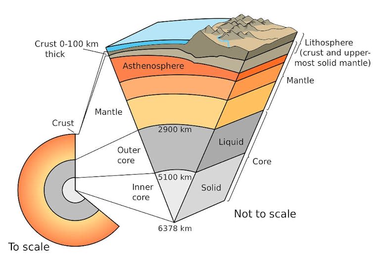
The mantle is the 2,900 km thick layer of the Earth that lies beneath the outer crust on which we live. To study what happens when continents break apart, we built advanced dynamic models to simulate the properties of the crust and mantle, and how they are physically stressed when forces are applied.
When continents break apart, hot rock in the mantle beneath them rushes up to fill the gap. This hot rock rubs against the cold continent, cools, becomes denser, and sinks, much like a lava lamp.
What had previously gone unnoticed was that this movement not only disrupts the region near the so-called rift zone (where the Earth’s crust is being pulled apart), but also the nearby roots of the continents. This in turn triggers a chain of instabilities, driven by heat and density differences, that propagate inland beneath the continent. This process does not happen overnight – it takes tens of millions of years for this “wave” to reach the deep interior of the continents.
This theory could have profound implications for other aspects of our planet. For example, if these mantle waves strip away 30 to 40 kilometers of rock from the roots of continents, as we propose, it would have a cascade of major effects on the surface. The loss of this rocky “ballast” would make the continent more buoyant, causing it to rise like a hot air balloon after it has shed its sandbags.
This uplift at the surface, which is happening directly above the mantle wave, should cause increased erosion by rivers. This happens because uplift lifts previously buried rocks, steepens slopes, making them more unstable, and allows rivers to carve deep valleys. We calculated that the erosion should be one or two kilometers, or in some cases even more.
The inner parts of the continents are considered the strongest and most stable parts of the planet, so it is not an easy task to deviate a few kilometers from these regions.
But at the edges of these stable continental areas, called cratons, we get kilometer-high escarpments, like those in Lesotho. These giant escarpments enclose these areas and extend for thousands of kilometers. They are evidence of a fundamental disruption of the landscape, at about the same time that the supercontinent Gondwana broke up – starting about 180 million years ago.
Mysterious plateaus
Inland from these great escarpments we find plateaus, such as the Central Plateau of South Africa, which rise more than a kilometre above sea level. The origin of these plateaus has long been a mystery and is generally not associated with the escarpments.
Some scientists have previously cited a phenomenon known as mantle plumes — colossal upwellings of hot, buoyant material from deep within the Earth — as a possible explanation for the plateaus.
Such plumes could potentially push up and dynamically support the Earth’s crust. However, there is no evidence for such an inner continental plume feature in geological records of surrounding continents or oceans over the relevant time period. Could our mantle wave provide a new explanation?
To test our predictions, we turned to thermochronology—a science that helps us understand how rocks, now on or near the surface, have cooled over time. Certain minerals, such as apatite, are sensitive to both temperature and time. Like a flight recorder, these minerals record a “cooling history,” providing snapshots of how the temperature of a particular rock has changed.
Here we used multiple existing measurements spread across Southern Africa. This analysis confirmed the predictions of our model: several kilometers of erosion occurred in the region at approximately the times that our models suggested. Even more remarkably, the erosion moved across Southern Africa in a pattern that closely matched the mantle wave in our simulations.
To explore this connection further, we applied another type of simulation, called landscape evolution modeling. This simulation examines how water interacts with the landscape and how the Earth’s surface effectively bounces or “bends” in response to the landscape shaped by rivers.
When we included the mantle wave in our computer model, it showed how it could theoretically form a plateau. Our results explain how vertical continental motions can occur far from active tectonic plate boundaries, where most uplift is generally known.
The massive erosion that occurs during these mantle wave events can lead to intense chemical weathering of rocks, which removes carbon dioxide from the atmosphere and promotes global cooling. These uplifts can also physically separate flora and fauna, leading to speciation and shaping evolution. We’ve come a long way in understanding the processes that lead to the formation of mountain ranges far from the edges of continents. And it still amazes me that it all started with an awe-inspiring view of the landscape of Lesotho.
This article is republished from The Conversation under a Creative Commons license. Read the original article.
Thomas Gernon receives funding from the WoodNext Foundation, a constituent fund managed by the Greater Houston Community Foundation.